What's New
Bug fix...
Bug fix...
Size:
830047
Category:
Business
Business
OS:
iOS
iOS
Price:
3.990
3.990
Compatible:
iPhone iPad
iPhone iPad
Requirements:
Version:
2.5
2.5
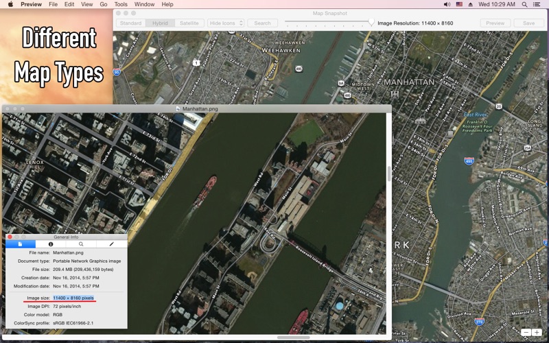
Description - Map Snapshot - Download Large Detailed Offline Maps As High Resolution Images
.
The Map Snapshot - Download Large Detailed Offline Maps As High Resolution Images is now available for 3.990 for both iPhone and iPad owners.The application is supporting English language. It is a whopper, weighing in at 830047, so make sure you have plenty of free space on your iOS device. The new Map Snapshot - Download Large Detailed Offline Maps As High Resolution Images app version 2.5 has been updated on 2014-09-11.
More Info: Find more info about Map Snapshot - Download Large Detailed Offline Maps As High Resolution Images in qin hu`s Official Website : http://enjoyableapps.wordpress.com/map-snapshot/
More Info: Find more info about Map Snapshot - Download Large Detailed Offline Maps As High Resolution Images in qin hu`s Official Website : http://enjoyableapps.wordpress.com/map-snapshot/
Map Snapshot lets you create big map images easily FEATURES + Create high resolution map images in JPEG or PNG. + Up to 100 times the resolution of the screen. + Option to hide icons for points ...
Snapshot presents you with an old road map with very few secondary roads a several year out of date satellite image or a combination It does what it says it will do you zoom into your area of interest set your resolution and it takes your fuzzy screen image and saves it as a very high resolution detailed file This does not happen in an instant Too bad you cannot draw or add anything to their image before saving the hi res file The old satellite images and no way to add to the map beforehand makes it not real useful to me But the latest Google Earth satellite images are copyrighted Old satellite images Superboar
does not show lakes of lekhnath municipality kaki NEPAL and seems the map is outdated wasted my money and time not worth jangajazz
Does what it says saves Apple Maps in any view up to 11 400 x 6000 in JPG or PNG format Timesaver Worth the 4 00 Dreamhome Radio
I have been using this app to download very high resolution images The app developer only says 100s of times screen size on the app description so I was a bit hesitant to purchase at first But it does in fact export at very high resolution so I no longer need to buy the Pro version of Google Earth to get full resolution maps I just now updated to the version with search and WOW Now its really awesome Very Helpful iWonderlander
Program outputs jpg not png images as displayed in the screen captures shown in the App Store Couldn t find any way of specifying the format for the image file Biggest issue is that when specifying a resolution one has no idea the level of detail the map will end up displaying It would be great if there was a preview or loupe revealing to what level of detail the map produced will show It is hard to relate the image resolution in terms of pixel dimensions and your big map might not include the street names for example requiring you to rerun the program multiple times to get what you want I thank the developer for providing this capability which actually should be built into Apple Maps Google Maps has a way of doing this although it requires some technical savvy in terms of URL API specifications This tool is great for saving a map for use when you won t have access to the internet another capability which Google supports and hopefully someday Apple will Map Snapshot would be a far superor product if one could drop map points on the map and then blow it up but at least using this program you can get large maps Rudimentry Tool Does what it says withtlc